
Zoning for aquaculture and biodiversity
Background
Aquaculture is the fastest growing food production industry in the world yet research and guidance demonstrating strategic multi-objective zoning for sector expansion is scarce. Quantifying and mitigating conflicts and impact on sensitive coastal environments through jointly-optimized objectives for aquaculture and biodiversity simultaneously has not been tested yet.
The planning area is one of the European Union highest priority bivalve shellfish aquaculture areas, the Emilia-Romagna Region in Italy. The region spans on the Emilia-Romagna marine waters (5256 km2), from the coast (approximately 120 km in length) up to the limit of Italian jurisdictional waters, including the territorial sea and high seas up to the midline (approximately 70 km), which is the international waters limit. The planning area was divided into 5,256 square planning units of 1km x 1km size.
Our study design consists of three main steps performed consecutively. Firstly, we organize and develop the three classes of spatial data layers required to underpin the analyses, which include: i) relevant conservation features (e.g. habitats and species); ii) aquaculture suitability and profitability surfaces; and iii) distributions of human activities and industries. Secondly, we construct six planning scenarios using different treatments of the three classes of data to identify priorities in either single objective plans using Marxan, or multi-objective plans using Marxan with Zones. Lastly, we conduct post-hoc evaluations across all scenarios using suitability analysis and a spatial similarity analysis based on a new analytic method.
We included 33 conservation features including seabed habitats (maerl bed, infralittoral fine sands, circalittoral fine sands, circalittoral sandy mud, circalittoral fine mud), and data for important species including: (Tursiops truncatus), seabirds and loggerhead sea turtles (Caretta caretta) species distributions, and nursery and spawning areas of commercially important fish species (Engraulis encrasicolus, Mullus barbatus, Pagellus erythrinus, Sardina pilchardus, Scomber colias, Scomber scombrus, Solea solea, Trachurus mediterraneus, Trachurus trachurus).
We developed aquaculture suitability scores, which we then vetted with national aquaculture experts. The process defined eleven important indicators related to three criteria: environmental quality, optimal shellfish growth conditions and socio-economic considerations. We assumed suitability scores of 0.6 or higher reflect sufficient environmental quality for shellfish growth.
We generated a cost surface reflective of human uses, which used the number of maritime industries occurring in each planning unit as a proxy for the transaction costs of negotiating biodiversity protection in each unit (e.g., the more industries, the higher the cost to conserve). We included the distributions of 12 industrial sectors and activities: aquaculture, coastal and maritime tourism, coastal defense works, dumping area for dredging, maritime transport, military areas, naval-based activities, off-shore sand deposit, oil and gas extraction, oil and gas research, small-scale fisheries, and commercial fishery.
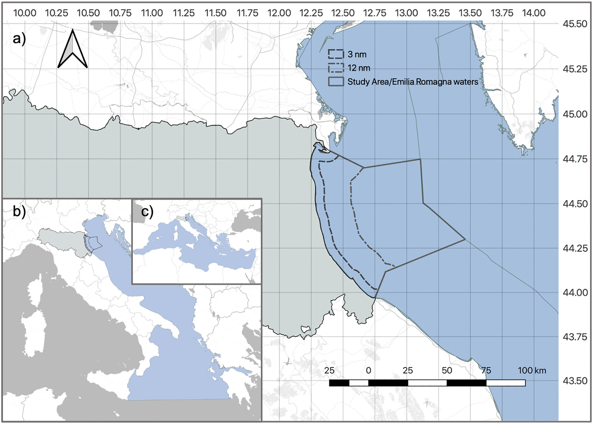
Study area boundaries (a) and their location in the Adriatic Sea (b) and in the Mediterranean Sea (c) context.
Photo credit: Jon Sullivan
Scenario construction describing how objectives, tools, targets, costs and BLM/ZBC vary across the six analyses
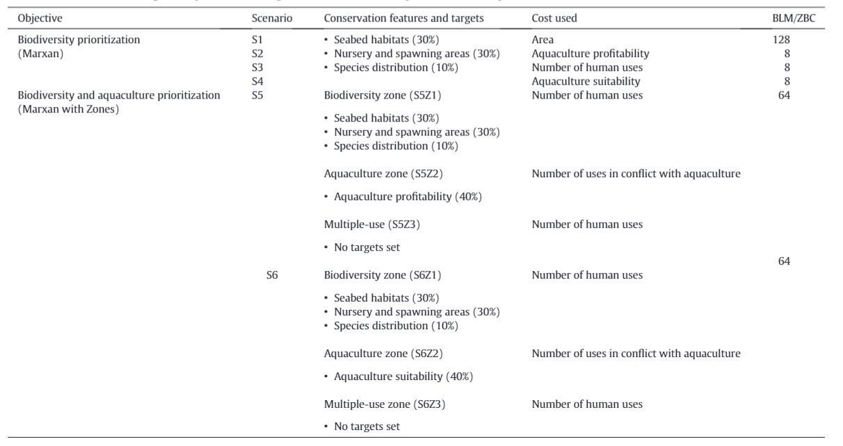
Photo credit: Chiara Venier
Photo credit: Chiara Venier
Reconciliation of competing human uses lay at the centre of marine spatial planning challenges in the Adriatic Sea. Therefore, we were primarily interested in understanding how priorities for biodiversity and aquaculture changed depending on the treatment of human uses and industries used in the prioritization analysis. We develop and evaluate six alternative planning scenarios for the region. We used Marxan and Marxan with Zones to meet predetermined targets for conservation features whilst minimizing impacts (also termed “costs”) to industries. We used different combinations of objectives, targets, Marxan softwares, and costs to develop six planning scenarios (Table 1). To reduce the spatial scattering and increase the compactness of the outputs in Marxan and Marxan with Zones scenarios we apply the boundary length between respectively planning units and zones.
For the single-objective scenarios important conservation features were assigned a 30% target in accordance with the world's oceans target established at the IUCN World Conservation Congress in Hawaii (2016). We also set 10% targets for broad ranging species distributions in line with Aichi Target 11 under the Convention on Biological Diversity (2010). For the first four scenarios, we kept these targets consistent while we varied the way in which the cost of a planning unit was calculated. The costs for the four scenarios were: S1) area of the planning unit - a baseline approach to set equal costs across the planning region so that priorities are solely determined by the conservation features, S2) aquaculture profitability based on the distance to port function, S3) human uses based on the number of maritime activities found in a planning unit and S4) the aquaculture suitability surface.
For the multi-objective scenarios, we developed two additional multi-objective prioritization scenarios (S5 and S6) aimed at simultaneously meeting targets for biodiversity and aquaculture whilst minimizing costs to maritime industries. Marxan with Zones allows for more sophisticated planning problems than standard Marxan, allowing users to make specific allocations of features, targets and costs to different more than just one kind of zone. We organized this analysis around three zones: Biodiversity (Zone 1) with the aim of conserving our biodiversity features; Aquaculture (Zone 2) with the aim of capturing suitable sites for aquaculture; and Multiple-Use (Zone 3) where any activity can take place, but which has no biodiversity or aquaculture targets set. We kept the biodiversity targets consistent with the single objective scenarios for the biodiversity zone, set targets for 40% for the Aquaculture Zone, applied to the profitability surface used in Scenario 5 (S5Z2) and the suitability surface used in Scenario 6 (S6Z2). We also applied two different treatments of the human use cost surfaces, using all human uses in the Biodiversity and Multiple-Use Zones and human uses deemed incompatible with aquaculture in the Aquaculture Zone.
Results
We compare results from different scenarios according to how well they capture suitable aquaculture habitats and minimize impacts. We introduce a new evaluation method for scenario comparison in spatial optimization using a nearest-neighbour analysis for spatial pattern similarities. Lastly, we test the “value of information” provided by our investment in developing the fine-scale suitability surface to improve efficiencies.
We found that planning for both biodiversity and aquaculture simultaneously resulted in more efficient conservation zones placed in areas less likely to generate conflict with other human uses, including aquaculture. Additionally, higher quality suitable habitat was retained for aquaculture zoning compared to when biodiversity alone was prioritized in an effort to minimize conflict with industries. Thus, we advocate for the integration of multi-objective seascape zoning to improve efficiency and minimize conflicts when industry and conservation are both considered parts of blue economic growth strategies. Further, embedding multi-objective optimization and decision-support tools into blue economy frameworks will help planners and stakeholders better understand the balances between objectives that need to reconcile critical biodiversity protection, food production and economic growth.
An important part of our analysis was developing a fine-scale suitability surface for the target aquaculture species. It takes a long time and substantial resources to gather the environmental and biophysical characteristics of the region, as well as validating weightings with regional experts on the ecological and socio-economic parameters affecting suitability. Given the investment in time and resources required to generate this suitability surface (S6), we also wanted to retrospectively understand the value of that information to inform the optimization compared to the proxy distance surface computed in less than 1 hour in a Geographic Information System - the profitability surface (S5). Value of information theory frames the investments scientists make in data collection in terms of its ability to help managers make better decisions. In spatial planning, value of information can help us direct limited resources towards collected data where it will reduce key uncertainties in our knowledge of marine ecosystem processes, and subsequently, impact or change what emerges as priority areas. Our analysis can be applied in any context where multiple objectives occur for aquaculture sector growth and biodiversity conservation.

Results from scenarios 1–4 showing the best solutions (top row) and selection frequencies (bottom row) where the cost surface changes.

Top row - Best Solution results for a) scenario 5 and b) scenario 6. Bottom row - Selection Frequency (SF) results for c) scenario 5 and d) scenario 6, where: Mostly biodiversity (dark green), when SF biodiversity ≥70%; Frequently biodiversity (light green), when SF biodiversity between 50% and 70%; Mostly aquaculture (dark blue), when SF aquaculture ≥ 70%; Frequently aquaculture (light blue), when SF aquaculture between 50% and 70%; Mostly multi-use (dark grey), when SF multi-use≥ 70%; Frequently multi-uses (light grey), when SF multi-use between 50% and 70%; Flexible (white), when the difference among the three zones is less than 15%. (For interpretation of the references to colour in this figure legend, the reader is referred to the web version of this article.)
References:
References
Chiara Venier, Stefano Menegon, Hugh P. Possingham, Elena Gissi, Andrea Zanella, Daniel Depellegrin, Alessandro Sarretta, Andrea Barbanti, and Jennifer McGowan. "Multi-objective zoning for aquaculture and biodiversity." Science of The Total Environment (2021): 146997.
Contact Information:

Chiara Venier
Institute of Polar Sciences (ISP), National Research Council, via Torino, #155 - 30172 Venice-Mestre, Italy

Stefano Menegon
Institute of Marine Sciences (ISMAR), National Research Council, Arsenale - Tesa #104, Castello 2737/F, 30122 Venice, Italy


