
The Red Sea Project
Background
The Red Sea Project (TRSP) is a development giga-project launched by the Kingdom of Saudi Arabia within its Vision 2030 plan to transform the nation. Vision 2030 sets to accomplish the diversification of the economy, creating a vibrant society, and new employment opportunities. TRSP aims to deliver on those commitments by improving the Kingdom’s tourism industry, which currently represents only 3% of the economy. The project extends over 28,000 km2 along the shores of the Red Sea that will progress to become a sustainable luxury tourism destination on the west coast of the Kingdom of Saudi Arabia aiming to support approximately 1 million visitors per year. The destination incorporates the Al Wajh lagoon, a pristine 2,081 km2 area that includes 92 islands with valuable habitats (coral reefs, seagrass, and mangroves) and species of global conservation importance. For instance, in the eastern boundaries of the lagoon, extensive coral reef formations occur at depths between 0.5 and 10 m. These are either continuous reefs that fringe the large islands’ coastline or patch and deeper reef formations that are in generally moderate to locally good condition, with live coral cover ranging from ∼30% to ∼70%. These represent some of the healthiest and most extensive coral reefs inside the TRSP lagoon. The genera responsible for building these coral reefs include branching growth forms, namely, Porites and Montipora, along with Acropora, Stylophora, Fungia, and Platygyra. Flat sandy bottoms as well as hardgrounds and coral rubble with fleshy macroalgae (Sargassum sp., Cystoseira sp., Laurencia sp., and Turbinaria sp.) dominate the shallow (0.5–1.5 m depth) coasts around the islands, with sparse Halodule sp. and Halophila sp. seagrass patches in between. In the intertidal zone, sparse mangroves (Avicennia marina) grow all along the insular coastline, locally presenting dense, impenetrable facies. The habitats present in the lagoon were classified into 27 habitat types and mapped through a combination of remote sensing and in situ ground truthing and biodiversity assessment surveys, which also documented existing impacts and pressures at the site. In addition, the site contains a number of species assessed as “threatened” (endangered, E, or critically endangered, CE) by the International Union for Conservation of Nature (IUCN), including 11 bird species (e.g., white-eyed gull, sooty falcon) and two sea turtle species (i.e., hawksbill sea turtle and green sea turtle). Human population in the area is low, with density within the 28,000 km2 being <0.1 person per km2. There are no residents or settlements in the islands; however, fishing activity is relatively high, with about 300 fishing boats operating in the region. No tourism activity currently exists in the area, but tourism development is considered to be a significant opportunity to create employment and enhance economic activity to reduce the dependence of the Kingdom of Saudi Arabia on fossil fuel revenues. By doing so, TRSP expects to create 70,000 new jobs, contributing over 22B SAR/year to the national economy. This commitment comes, however, with an ambition to create net positive impact and increase the conservation value of the site by 30%. However, whether the level of tourism considered to be sustainable in the Al Wajh lagoon can be compatible with the conservation targets set by TRSP and what specific spatial arrangement may lead to this balance need be assessed. MSP provides, therefore, an effective, and even necessary, approach to seek the optimal way to balance conservation goals with tourism development goals.
Green Sea Turle (left) copyright creative commons
The Red Sea Development Company (TRSDC), responsible for the execution of TRSP, has committed to achieve a net-positive impact on biodiversity and increase the conservation value of the site by 30%. This requires reaching conservation outcomes superior to those of a “business as usual” scenario for an undeveloped site. In our case, the “business as usual” scenario refers to the state of study area in the absence of any development, but under the chronic impacts being in place. These threats include overfishing, reflected in the scarcity of large and small fish stocks, bycatch mortality of turtles and dugongs, local extirpation of birds and other vulnerable species by invasive species (rats and cats) present in some of the islands, plastic litter that abounds on the shores, mortality caused by ghost nets abandoned at sea, and climate change. After careful optimization of the development plans to explore every opportunity to avoid impacts, we applied marine spatial planning (MSP) to answer the query of whether MSP can, when supported by conservation measures, drive coastal tourism into shifting roles in the 21st century from being a threat toward conservation and thus achieving net positive conservation benefits. We incorporated people involved in TRSP stemming from different backgrounds through the entire MSP process, and we tested five conservation scenarios (excluding and including development) using Marxan, a suite of tools designed to identify priority areas for protection on the basis of prescribed conservation objectives. Also, we quantitatively assessed the conservation value of the areas chosen for protection by Marxan, to conduct a preliminary zoning for the site and we finally reported on the suggested regulation for each zone as well as the key actions to be implemented by TRSDC to achieve net positive conservation benefits for TRSP area.
Avoiding Development Impacts
An interdisciplinary team involving the chief executive officer (CEO) of TRSDC, the chief development officer, concept master planners, architects, marine and transportation engineers, utility managers, environmental regulators, and marine scientists was assembled to explore every option to avoid impacts in the concept master plan that would dictate how the Al Wajh lagoon will be developed while achieving net conservation benefits. This was effected through the series of 15 environmental baseline surveys conducted during 2017 and 2018 but also through monthly environmental alignment workshops conducted for about 1 year prior to the marine spatial planning (MSP) exercise, during which a broad range of actions were taken. These actions included (a) modifying the designs to avoid proximity to habitats and nesting sites of conservation value, implementing buffer zones; (b) minimizing intervention in the area; (c) reducing the density of the development to avoid potential noise and light impacts; and (d) reducing resources (e.g., energy, all of which will be from renewable sources and water, required to operate the development). These assessments were focused on individual development sites, i.e., individual islands, and were informed by the habitat and species baselines, leading to over 18 iterations of development plans and displacement of development from nine islands of high conservation value (“set aside islands”) to minimize impacts. The resulting development footprint was then used to inform, along with the habitat and species maps, a holistic planning approach that required an exercise in MSP effected through a workshop involving all TRSP departments and elements that informed subsequent modeling of the conservation zoning for the site.
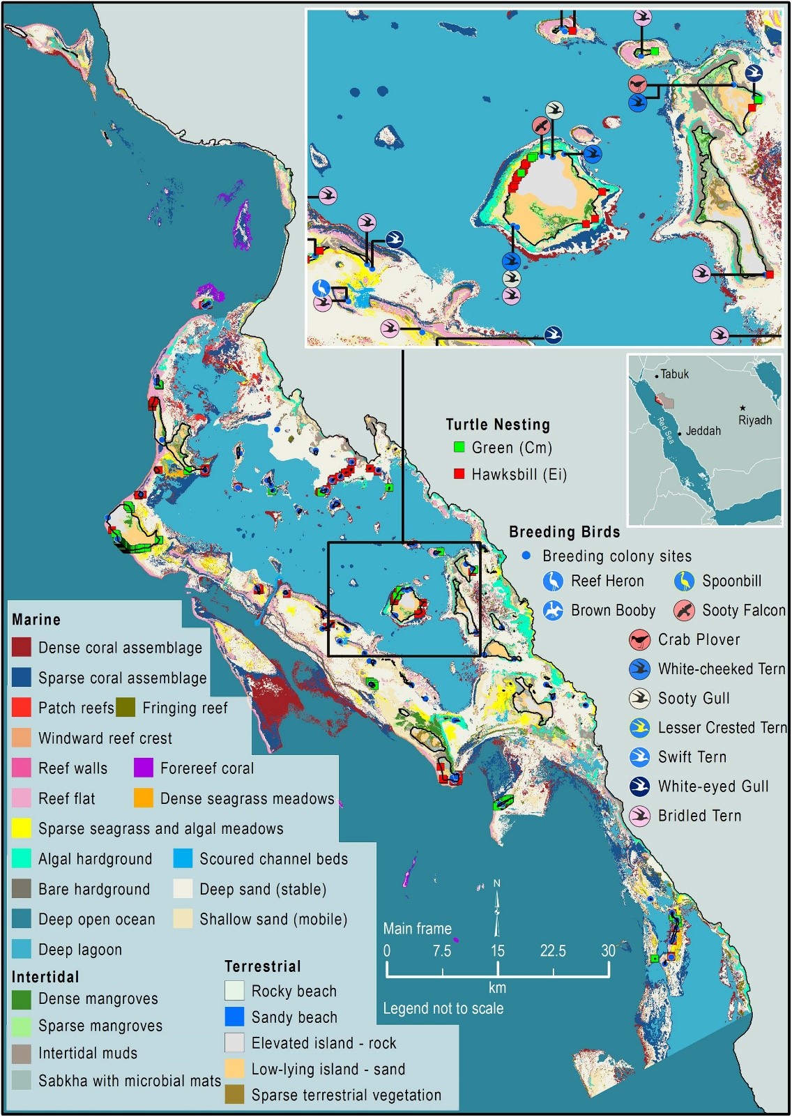
The Al Wajh lagoon, on the northeastern part of the Red Sea, the site of the Red Sea Project (RSP) development. The map shows the distribution of the 27 habitats and the nesting sites for the 11 species within the Red Sea Project boundaries.
Red Sea, copyright creative commons
Scenarios
Our conservation models assessed two groups of scenarios, one including conservation only and one examining conservation in the presence of development. The rationale of this grouping was to explore the nexus of conservation and development in the area, thus challenging the project pledge to achieve net positive conservation impact through thoughtful sustainable development. In particular, we created five scenarios: three scenarios considering only conservation, based on three increasingly comprehensive groups of conservation targets (six habitats of high conservation value, all habitats, other than the terrestrial ones and the deep open ocean, and all habitats plus 11 species of high conservation value, i.e., two sea turtle species and nine bird species), without considering any development plans. By progressively adding conservation targets to the analysis, we assessed whether targeting the most valuable habitats provided a surrogate for broader conservation targets, as assessed in the past, including the Red Sea. We note that only birds and sea turtle species of conservation concern were explicitly considered among the hundreds of species present in the area. The reason for this was that birds and turtles have vulnerable stages (i.e., nesting) of their life cycles on land, where marine habitats are not defined. We also evaluated two scenarios to assess if similar conservation targets as those in the absence of development could be achieved in the presence of development. The first scenario of this group entailed all habitats and species (as per scenario Cons_h+s) but also considered the development elements as areas a priori excluded from conservation. In the second scenario of this group, the nine islands decided by TRSDC to be set aside for protection were also included in the analysis, as a priori selected for conservation in order to evaluate how this decision quantitatively affects the final conservation outcome. All scenarios were processed using the software-based decision support tool Marxan v 2.43 to select areas for conservation. The study area was divided in 32,398 square PUs of 0.25 km2 each. The dimensions of the PUs (500 m × 500 m) were defined by the spatial accuracy of the available data and the desired analysis output (i.e., to fit the buffer zone around species’ nests; 500 m; decided by the experts on the environmental alignment workshops). We set Marxan to retain 99 and 90% of the area of high-value habitats (six habitats, all five scenarios) within conservation zones. In addition, we prescribed 50–80% of the area of other habitats (11, in four of the scenarios) to be retained within the conservation zones. Similarly, Marxan was used to conserve 90 and 100% of high-value nesting habitat (for the high-priority species) and 70% of low-value nesting habitat for each of the 11 priority conservation species included within conservation zones.
Marine Spatial Planning Team and Workshop
In the case of TRSP, engaging affecting or affected parties, such as tourists and working force, could not be achieved due to the fact that no activities, other than fishing involving almost 300 of artisanal boats, are currently occurring in the area which is characterized by minimal resident population. However, fishermen do not operate in a systematic way and do not form an organization or a union as in other countries (e.g., Portugal). In addition, national legal regime poses strict limits regarding opinion polling and consultation of the local population. Therefore, engagement of the local communities could not occur in our case. For this reason, and through the commitment of TRSDC to conservation planning, we designed a stakeholder simulation that brought actors with all required backgrounds (e.g., concept master planners, managers, architects, engineers, ecologists) to an MSP workshop to gain a shared perspective of how the entire site, and not its individual components, ought to be zoned to achieve the target of sustainability and potentially net positive conservation benefits through development. The platform for this exercise was a workshop, conceived as a board game where “players,” i.e., workshop participants, experience some of the dynamic and complex interaction between development and conservation. “Players” were tasked to come up with creative solutions to resolve conflicts between development and conservation goals through tactical changes in the development plan. In order to achieve this, the workshop included as participants key members of the RSP team (e.g., utility and transportation managers, engineers, architects), all engaged in different disciplines, among whom the CEO and directors of the various departments participated in the process. Their combined knowledge while examining the area in a holistic way proved crucial for the success of the workshop.
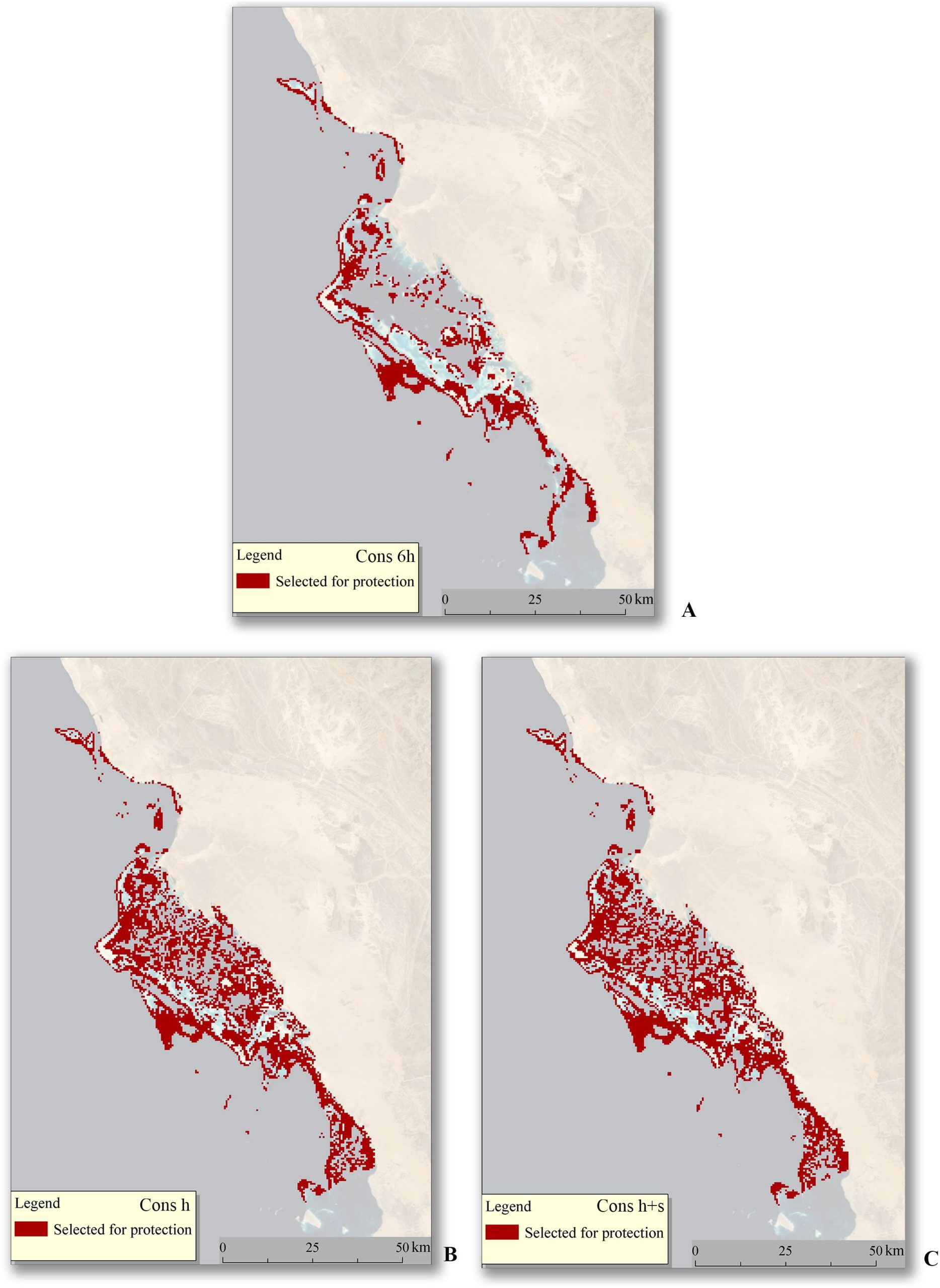 Spatial distribution of the selected planning units (PUs). The total area of the site was 2,081 km2. (A) For the “Cons_6h” scenario, where targets only for six key habitats were considered, the area selected for protection was 684 km2. (B) For the “Cons_h” scenario where targets were set for 17 habitats, the area selected for protection was 1,214.8 km2. (C) For the “Cons_h+s” scenario where targets were set for 17 habitats and 11 species, the area selected for protection was 1,232.5 km2.

Ten key actions to be implemented by The Red Sea Development Company (TRSDC) to achieve net positive conservation benefits for The Red Sea Project area.
Zoning
The PUs selected by Marxan for each of the five scenarios were needed to meet the set of conservation targets, but they likely differed in their individual contribution to this target, as inspection of the base habitat and nesting map shows that many habitats and species of high conservation value tend to co-occur. We, therefore, developed a methodology to estimate the cumulative conservation value of each scenario, as well as the contribution of each individual PU selected to this total value. This was achieved by assigning a discrete conservation value ranging from 0.5 to 5 to each habitat and species conforming to the scenario, with the conservation value being positively correlated to the conservation target (e.g., a species with the maximum conservation target of 100% target bears the maximum conservation value of 5). More explicitly, for each PU selected for protection, the percentage of each ecological feature contained in this PU with respect to the total area of the feature selected for conservation in the scenario was calculated. This ratio was multiplied to the preassigned conservation value of the feature. The sum of all these products provides the conservation value of each PU. The sum of the conservation values of all the selected PUs resulted in the cumulative conservation value of the scenario. The latter allowed for the visualization of the most “valuable” cells as well as the quantitative assessment of what it is conserved by Marxan per scenario.
We succeeded in creating a three-layer conservation zoning, achieving conservation outcomes as those possible in the “business as usual” scenario. We identified that the conservation zoning of the TRSP emerging from the MSP exercise, including iterative workshops to avoid impacts through changes in design and conservation modeling reaches similar conservation outcomes in the presence of development as if the whole area was declared an MPA (1,219 km2 conservation area required). The “top conservation zone” consists of the PUs (20% of the total 32,399 PUs) included in the two highest classes of the quantile separation, comprising cells within the upper 40% of the range of conservation scores of the selected PUs. The “top conservation zone” contains the most valuable cells according to the classification and refers to the most important habitats and should be dedicated only to conservation, research and monitoring. Only guided tours of small groups of visitors for educational purposes would be permitted in this area. The “high conservation zone” formed by the PUs comprising the lower 60% of the range of conservation scores of the selected PUs include 30% of the total 32,399 PUs. This zone will be subject to severe restrictions defining the mobility of humans, the transportation means, and the infrastructure permitted. No permanent structures would be developed within the boundaries of this zone (e.g., hotels or jetties). Finally, the “development zone” (5% of the total PUs) accommodates all the development elements and activities. However, this zone is also facing limitations as the whole area of the lagoon is defined as critical habitat. These include specific buffer zones around vulnerable habitats and nesting sites and strict management of light, noise, and litter. Subsequently, TRSDC designed additional actions to remove existing pressures and generate net positive conservation outcomes. For instance, all transport will be conducted by electric vehicles, power will be generated by renewable technologies, single-use plastic will be banned, no brine will be discharged within the lagoon, 100% of freshwater will be reused (other than evaporative losses), and recycling aims at no waste to landfills. Indeed, TRSP pledges an increase in net conservation value, of 30% in 20 years compared to the “business as usual” scenario. The results demonstrate that careful design and planning could potentially allow coastal development to enhance, rather than jeopardize, conservation.

Preliminary zoning of the site. The deep blue grid cells constitute the “top conservation zone,” the light blue grid cells form the “high conservation zone,” the gray grid cells create the “development zone,” and the purple grid cells are the set-aside islands which are part of the “top conservation zone.” All the rest are non-allocated areas.
References:
References
Vasiliki I. Chalastani, Panos Manetos, Abdulaziz M. Al-Suwailem, Jason A. Hale, Abhishekh P. Vijayan, John Pagano, Ian Williamson, Scott D. Henshaw, Raed Albaseet, Faisal Butt, Rusell E. Brainard, Harry Coccossis, Vasiliki K. Tsoukala and Carlos M. Duarte. 2020. Reconciling Tourism Development and Conservation Outcomes Through Marine Spatial Planning for a Saudi Giga-Project in the Red Sea (The Red Sea Project, Vision 2030)." Frontiers in Marine Science 7:168. https://doi.org/10.3389/fmars.2020.00168
Contact Information:


Carlos M. Duarte
King Abdullah University of Science and Technology Thuwal, Saudi Arabia


