Planning for the Daly catchment
Background
The in the Northern Territory (NT), Australia, is approximately 5.2 million ha, extending from the coastline southwest of Darwin to 250 km inland. Approximately 13% of the catchment is currently protected by national parks and Indigenous protected areas, while about 6% has been cleared of native vegetation (or at least the native overstorey) for different intensive land uses such as cropping and modified pastures. The Daly catchment has been recognized both for its high conservation values and potential for future agricultural development due to a unique combination of suitable soils, year-round water supplied by large aquifers and the perennial Daly River, and suitable climatic conditions (adequate rainfall during the growing period) for rainfed crops. Also, an emerging market for offsets to reduce carbon emissions based on improved fire management of tropical savannas could provide an important commercial opportunity for grazing properties and Indigenous lands in the region.
Planning process and objectives
In response to potentially competing interests in the management of the Daly catchment (e.g., conservation, agriculture, recreation), the former Daly River Management Advisory Committee (DRMAC) commissioned a development and conservation plan for the catchment in 2011. The planning process was designed by us in collaboration with DRMAC with the intent of producing an agreed-upon land-use scenario to support the ongoing adaptive planning and management of decisions about natural resources over management relevant time-frames of 5–10 years.
Defining objectives involved first describing a number of broad, qualitative goals and then translating these into quantitative objectives to inform land-use scenarios (for a full discussion of the objective setting process see). The plan objectives cover development (e.g., maximum percentage of catchment cleared for agriculture), further protection of conservation features (e.g., protection of 17% of all vegetation types), and supporting alternative commercial opportunities (e.g., carbon offsets). A stakeholder engagement process was designed in collaboration with DRMAC to inform the plan objectives and ensure the plan outcomes were aligned with stakeholder values. The engagement process extended over the duration of the planning process (2012–2014) and included community forums, focus groups, and a survey to all catchment residents. The stakeholder engagement ensured that all plan objectives identified by DRMAC were also aligned with stakeholder values. Therefore, the plan objectives remained broadly the same as those initially identified by DRMAC, with the exception of two objectives (maximum clearing and agricultural precincts) that were varied across scenarios.
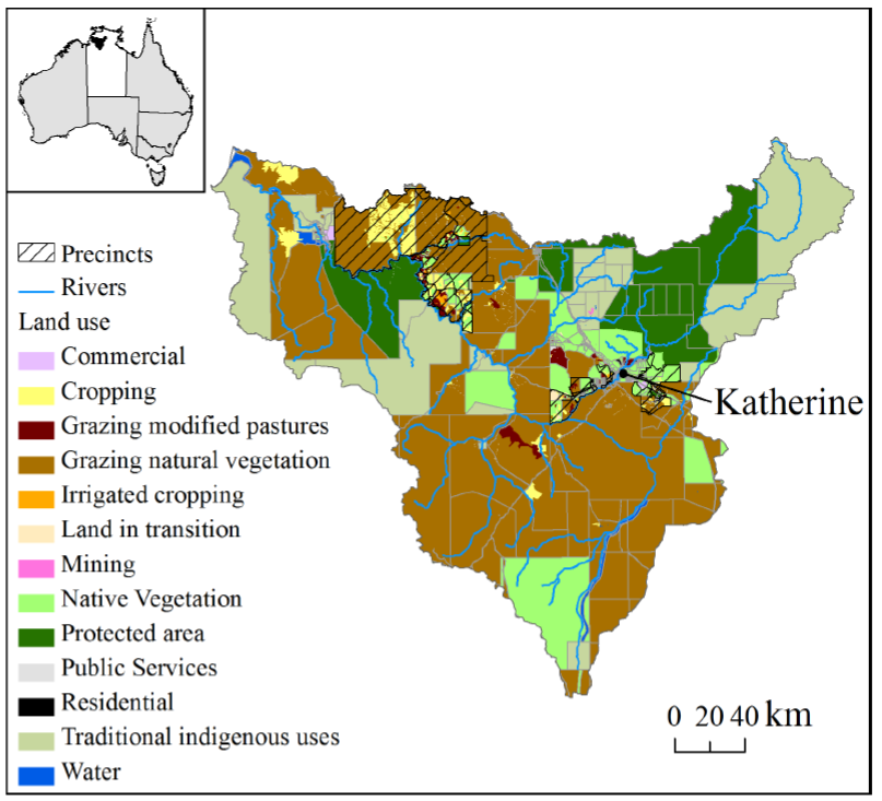 Daly catchment property boundaries and land use as defined by ABARES Land use mapping. Inset shows the Northern Territory (white) and the Daly catchment (black)
 Land-use scenarios
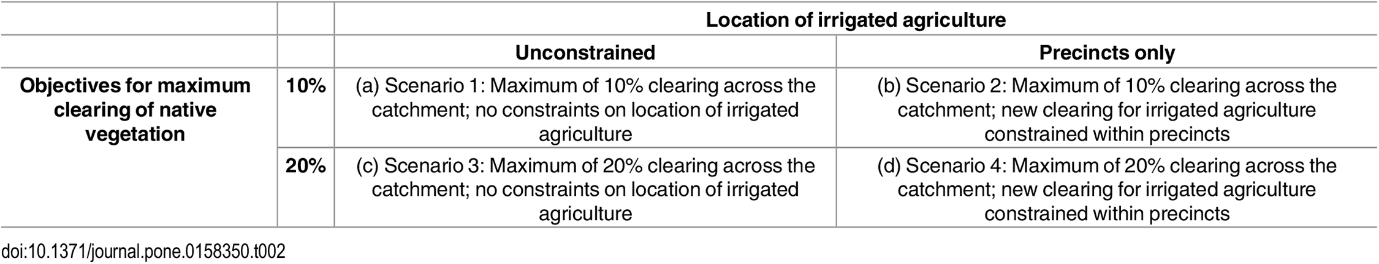
Four land-use scenarios were developed by varying two objectives related to development: total land cleared across the catchment; and spatial constraint on location of new irrigated agriculture (constrained to precincts or unconstrained). The objectives for conservation (i.e. protection of native vegetation, native species, and sites of conservation significance) and ecosystem services (i.e. abatement of carbon emissions through improved savanna burning) were constant across scenarios.
Results
The four land-use scenarios were spatially distinctive. The objectives for conservation and savanna burning were constant, resulting in very similar spatial placement and quantity of land selected for these uses across scenarios. About 1.10 (varying from 1.08 to 1.11) million ha were selected for protection and 0.713 (varying from 0.712 to 0.716) million ha for savanna burning. Five conservation objectives could not be met due to current land uses. These were the 100% objectives for wetlands and rainforest and for three of the five Sites of Conservation Significance: Daly River Middle Reaches, Western Arnhem Plateau, and Anson Bay. There were no other shortfalls for conservation objectives across the four scenarios. The scenarios varied according to objectives for total clearing and location constraints for irrigated agriculture, resulting in differences in configuration and extent of agricultural land uses. However, there were spatial locations that were consistently selected for particular agricultural land uses across scenarios.
Planning for multiple land uses requires navigating trade-offs between social, commercial, and environmental outcomes arising from different possible futures. Our study illustrates one method of incorporating stakeholder preferences, associated with development and conservation, into both the design and evaluation of land-use scenarios. Furthermore, our study presents an example of how scenarios can be designed using existing decision-support tools for optimal allocation of land uses, thereby ensuring multiple objectives are met while minimizing potential conflicts between competing interests.

References:
References
Adams, V.M., Pressey, R.L. and Álvarez-Romero, J.G., 2016. Using optimal land-use scenarios to assess trade-offs between conservation, development, and social values. PloS one, 11(6), e0158350. https://doi.org/10.1371/journal.pone.0158350
National Environmental Research Program (NESP). 2015. Planning for the Daly catchment Research update. https://www.nespnorthern.edu.au/wp-content/uploads/2015/11/1.1_fact_sheet_web.pdf
Contact Information: