Dynamic planning in the Gulf of Carpentaria
Background
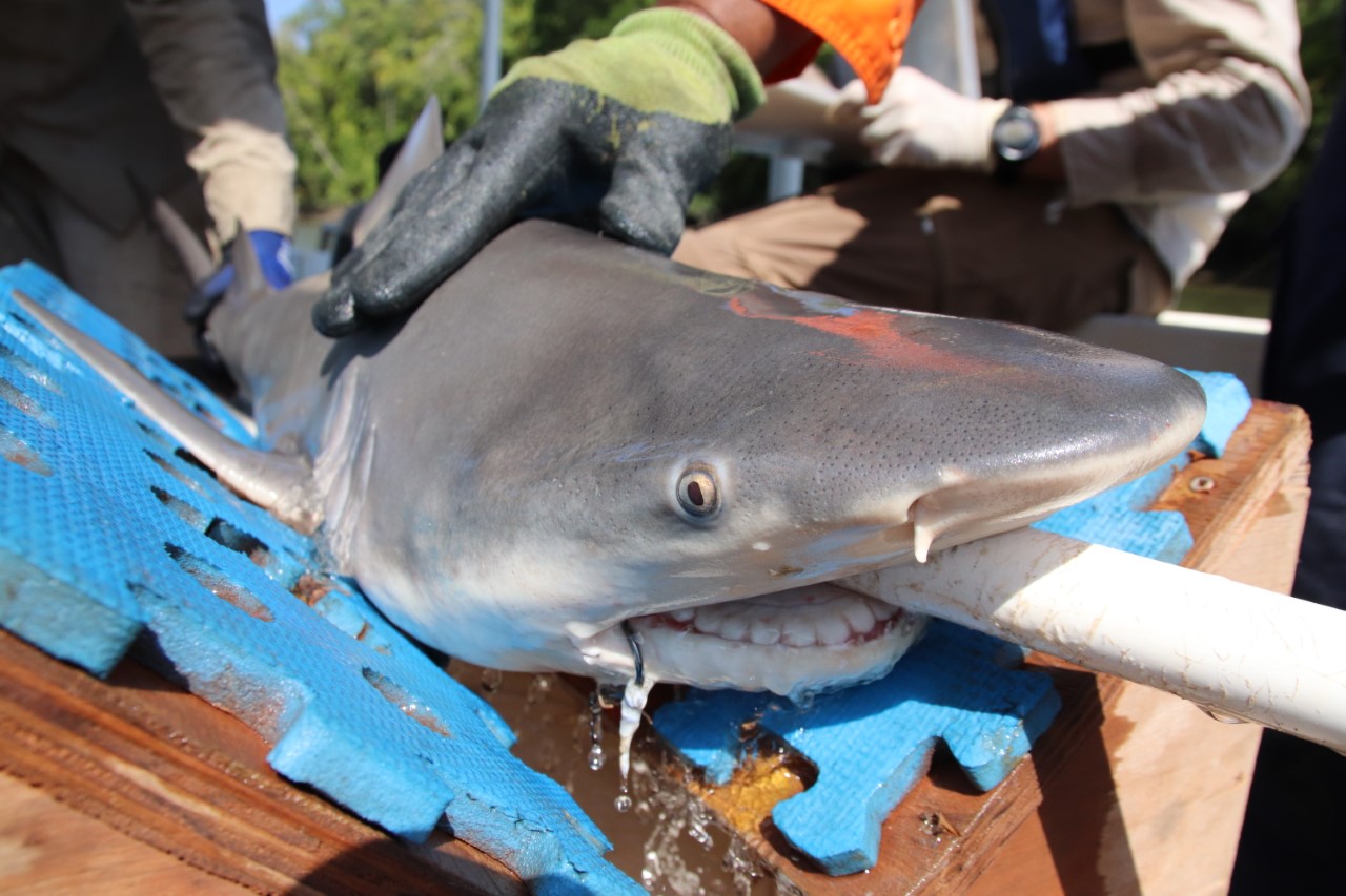
The speartooth shark (Glyphis glyphis) is a medium-sized whaler shark (Carcharhinidae) listed as endangered on the International Union for the Conservation of Nature Red List and critically endangered under the Australian Government’s Environment Protection and Biodiversity Conservation (EPBC) Act 1999. Although little is known about the movements of adult sharks, juvenile speartooth sharks are limited to a small number of tidal rivers in northern Australia and New Guinea. Their restricted distribution, naturally low densities, specific habitat requirements, and strong adult female philopatry make the species particularly vulnerable. Incidental bycatch from fisheries is the primary process threatening population viability. In Queensland speartooth sharks are found only in the Wenlock and Ducie River systems in northwest Cape York. Juvenile speartooth sharks share these nursery areas with commercial net-fishing operators targeting barramundi (Lactes calcarifer), as well as recreational, charter boat, and indigenous fishers. Together these form part of the Gulf of Carpentaria Inshore Finfish Fishery. Commercial gillnet fishers operate in estuarine and coastal areas in this region, but waters within 1 km of the western shore of Port Musgrave are permanently closed to commercial gillnetting. In addition to this permanent closure, a state-wide seasonal closure prevents commercial and recreational targeting of barramundi in the Gulf of Carpentaria between 7 October and 1 February to protect spawning adults. The other dominant commercial activity in the region is potting for giant mud crab (Scylla serrata), which occurs year-round in mangrove and mudflat-dominated estuarine habitats. Despite the speartooth shark’s imperiled status, known susceptibility to gillnets and set pots, and their listing as a protected (no-take) species under the Queensland Fisheries Act 1994 and Fisheries Regulation 2008, no spatial conservation measures exist in the catchment to limit their bycatch.
The optimal design of reserve networks and fisheries closures depends on species occurrence information and knowledge of how anthropogenic impacts interact with the species concerned. However, challenges in surveying mobile and cryptic species over adequate spatial and temporal scales can mask the importance of particular habitats, leading to uncertainty about which areas to protect to optimize conservation efforts. We investigated how telemetry-derived locations can help guide the scale and timing of fisheries closures with the aim of reducing threatened species bycatch.

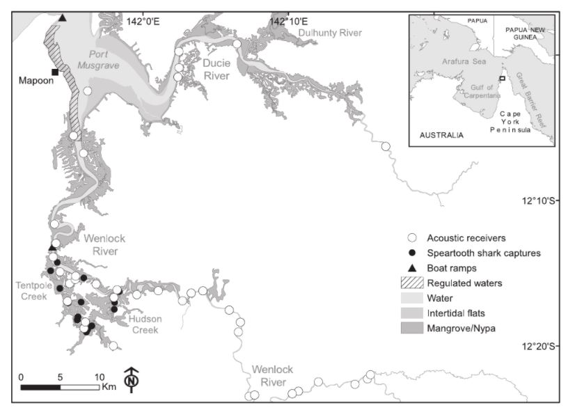
Locations of juvenile speartooth shark captures and acoustic hydrophone receivers and of intertidal zones, mangrove areas, boat ramps for commercial fishing vessels, and regulated waters closed to commercial netting on the western shore of Port Musgrave in the eastern Gulf of Carpentaria, Australia.
Forty juvenile speartooth sharks (Glyphis glyphis) were monitored over 22 months with implanted acoustic transmitters and an array of hydrophone receivers. Using the decision support tool Marxan, we formulated a permanent fisheries closure that prioritized areas used more frequently by tagged sharks and considered areas perceived as having high value to fisheries. To explore how the size of the permanent closure compared with an alternative set of time-area closures (i.e., where different areas were closed to fishing at different times of year), we used a cluster analysis to group months that had similar arrangements of selected planning units (informed by shark movements during that month) into 2 time-area closures.
Results
Sharks were consistent in their timing and direction of migratory movements, but the number of tagged sharks made a big difference in the placement of the permanent closure; 30 individuals were needed to capture behavioral heterogeneity. The dry-season (May–January) and wet-season (February–April) time-area closures opened 20% and 25% more planning units to fishing, respectively, compared with the permanent closure with boundaries fixed in space and time. Our results show that telemetry has the potential to inform and improve spatial management of mobile species and that the temporal component of tracking data can be incorporated into prioritizations to reduce possible impacts of spatial closures on established fisheries.

(a) Priority fisheries closures derived from achieving a 50% target of river use for all tagged speartooth sharks during the entire 22 months of detection. Priority areas are based on selection frequencies from 100 runs. The darker the planning unit the higher the selection frequency. (b) Comparison of the difference in selection frequency between scenarios informed using shark tracking data gathered during the dry (May–January) and wet seasons (February–April). Highly selected areas are planning units selected ࣙ20 times for both wet and dry scenarios.
References:
References
Dwyer, Ross G., et al. "Using individual‐based movement information to identify spatial conservation priorities for mobile species." Conservation Biology 33.6 (2019): 1426-1437.
Contact Information: