Tuna Conservation in Gulf of Mexico
Background
Marine migratory species seasonally travel long distances to fulfill needs such as foraging and reproduction. It’s critical for survival of these species that their pathways are clear of threats. Threats to migration include human activities, climate change, habitat loss, and environmental pollution.
The Gulf of Mexico hosts a wealth of migratory fish, sea turtles, birds, and marine mammals. It is also a hub for human activities such as offshore energy development, shipping, commercial and recreational fishing, and tourism. Without spatial planning, these human activities can block migratory corridors of these species and prevent them from completing their life cycles.
Tunas are highly migratory species that connect habitats, populations, and economies in the Gulf with those in the northeast U.S, Europe, and west Africa. These fisheries are particularly valuable for coastal economies in the Gulf.
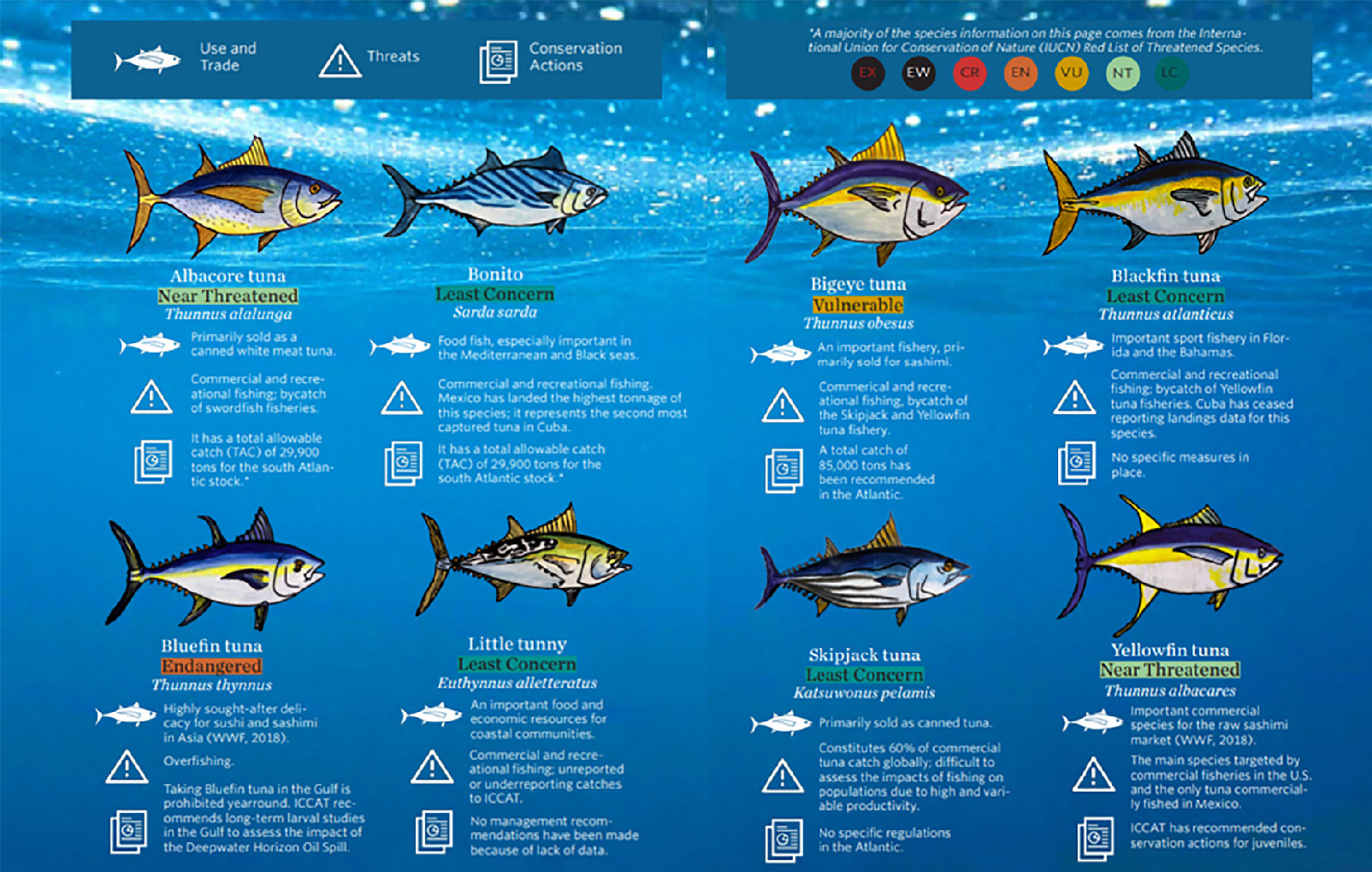
Marxan was used to identify critical areas for management of eight species of highly migratory tunas in the Gulf: albacore tuna, bigeye tuna, blackfin tuna, bonito, little tunny, skipjack tuna, and yellowfin tuna. Based on the IUCN Red List, half of these species are near threatened or threatened.
Publicly available data was aggregated from multiple sources to generate seasonal species distributions. These data points represent observations from periodic research cruises and citizen science, fisheries catch data, tag-recapture locations, and fish larvae from systematic field surveys. While more detailed telemetry data tracklines were shared with this study, these datasets were not used to generate the seasonal distributions or used in Marxan analyses as they were only available for bluefin tuna.The density maps generated from occurrence points greatly improved upon the IUCN Red List’s global species distribution datasets.
AIS data from Global Fishing Watch for 2012 to 2017 were compiled and averaged seasonally. These seasonal layers were then combined with relevant cumulative human impacts layers for 2013 from Halpern et al. (2015). The human impact layers include shipping lanes, pollution, offshore energy activity, invasive species, and fisheries activities.
Due to the seasonal nature of fish migrations and of human offshore activities, this analysis identified critical locations for tuna management both spatially and temporally by conducting four separate Marxan scenarios for Spring, Summer, Fall, and Winter.
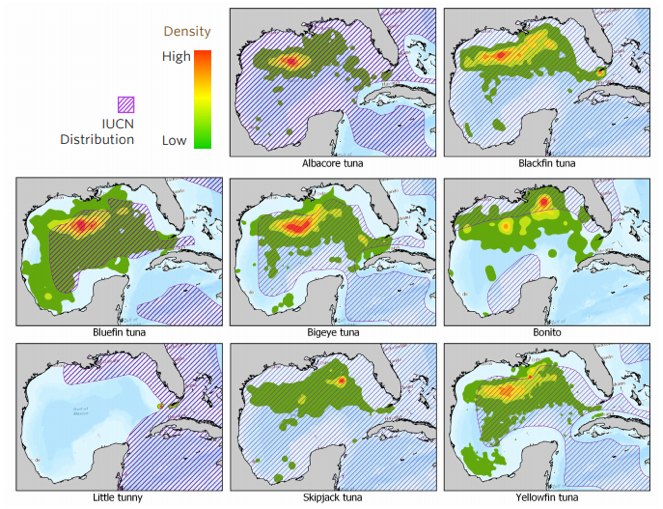
Comparison of species distributions models and species range maps.
Planning Objectives
Conservation Targets: Threatened species were weighted more heavily in this analysis by scaling conservation targets according to each species’ IUCN Red List Status: Near Threatened (NT) as 20%; Vulnerable (VU) as 30%, Endangered (EN) as 40%, and Critically Endangered (CR) as 50%.
Strata: The three exclusive economic zones (EEZs) in the Gulf – U.S., Mexico, and Cuba – were extended manually to divide the two international regions equally between the three countries. This revised EEZ layer was used as modeling strata in each Marxan analysis so that the goals set for each conservation target would have to be met within each country’s jurisdiction. The seasonal Marxan scenarios were run with and without these strata. Both results were then aggregated into the final priority areas, so that priority areas for management within each country and in the Gulf overall would be identified. This step was critical for reducing errors due to the geographic bias of available observation datasets.
Existing protected areas were not locked into any of the Marxan scenarios.
These planning objectives were selected as the most relevant for fisheries management after executing multiple Marxan scenarios with varying inputs and consulting with stakeholders.
RESULTS
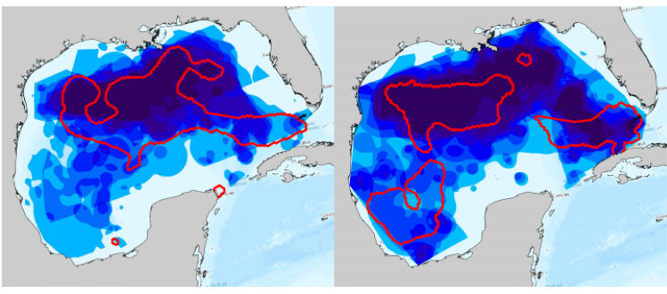
Fall priority areas Winter priority areas
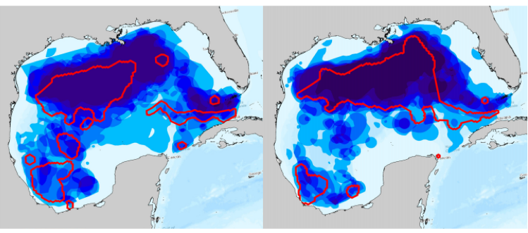
Spring priority areas Summer priority areas.
Less than 2% of these areas were protected as of the completion of this analysis in 2018. However, effective management of these fisheries was identified as a critical need, rather than protection. The goal of these maps is to inform management decisions such as seasonal fishing closures.
Prior to this analysis, NOAA had identified two regions in the Gulf as critical for improving management of bluefin tuna under Amendment 7 to the 2006 Consolidated Highly Migratory Species Fishery Management Plan (NMFS, NOAA 2014). In these areas, measures were enacted to prevent overfishing and rebuild stocks, minimize bycatch, reduce dead discards, and improve the scope and quality of catch data (NMFS, NOAA 2014). The seasonal Marxan results support the management of these areas and further demonstrate that they are important regions for all eight species of tuna in this analysis during all seasons.
This analysis also helped to identify key data gaps and needs for additional studies and fisheries management actions. The results of this analysis were compiled into a report and toolkit for use by fisheries managers and policymakers in the U.S., Mexico, and Cuba. The complementary Blueways Conservation decision support tool provides stakeholders with interactive support for decision-making.
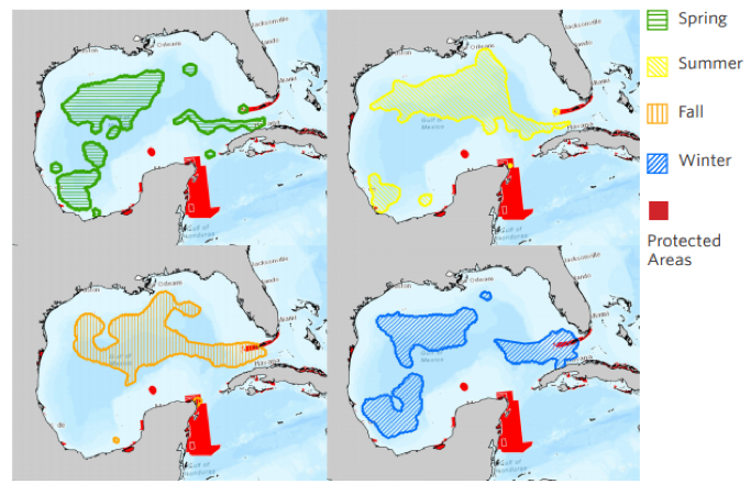
High priority areas for tuna and existing protected areas.
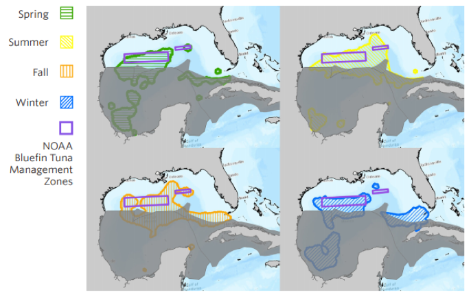
Additional NOAA management zones and key gaps in the protection of high priority areas through seasons identified from Marxan results.
References:
Contact Information: