National planning in Guyana
Background
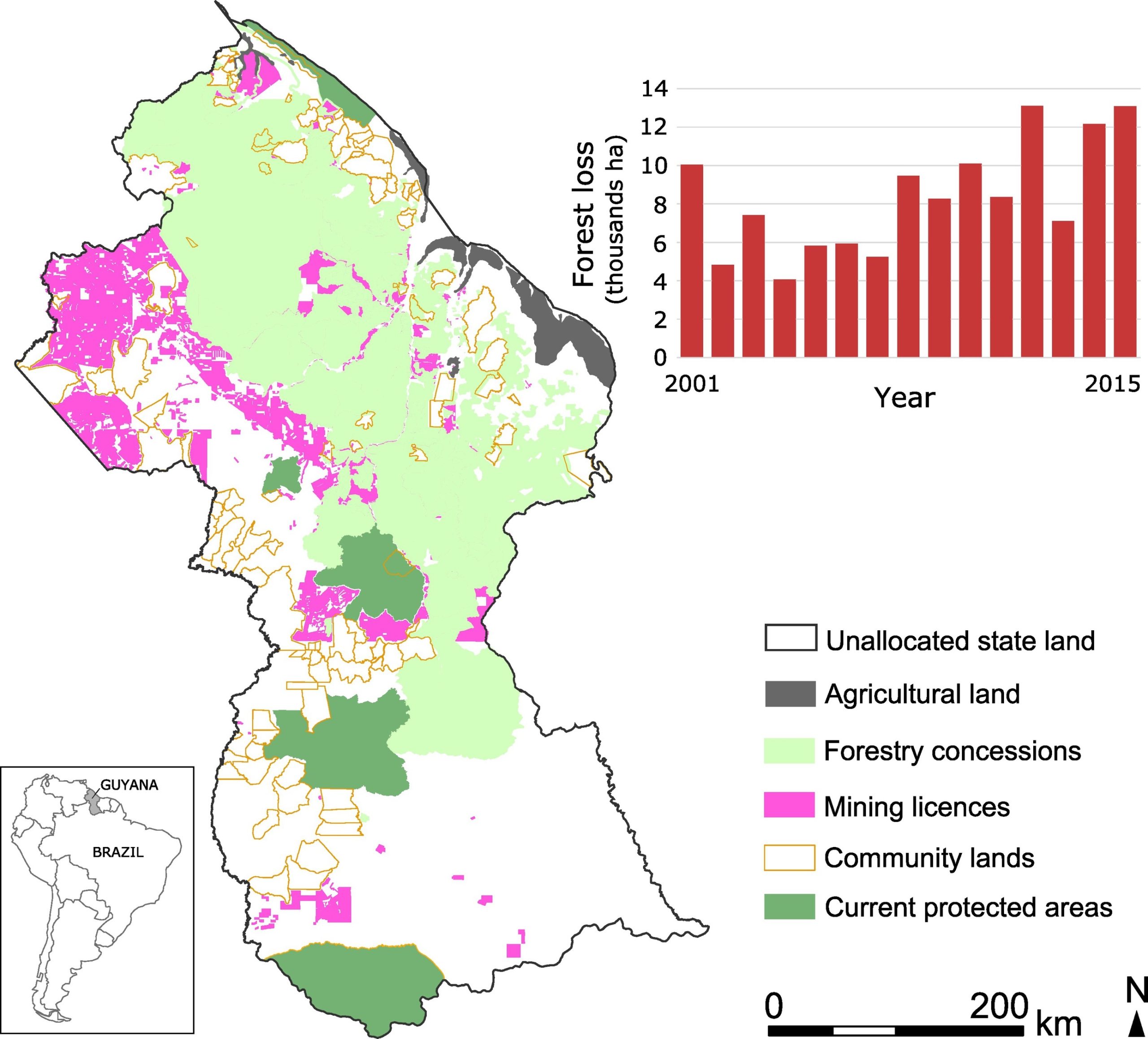
Guyana forms part of Amazonia and combines economic poverty with some of the highest global levels of biodiversity, and lowest deforestation rates. Over 80% of the land area is covered with tropical forest. However, as in many parts of South America, deforestation rates have risen over the last decade, primarily as a result of gold mining. This was partly because forests produced little government revenue compared with mining. This situation changed in 2009, when Norway committed up to $250 million to Guyana over an initial five-year period for Reducing Emissions from Deforestation and forest Degradation (REDD+). More recently, large amounts of offshore oil have been discovered in Guyana’s waters, and now the country’s economy is set to be transformed over the next decade. The expectation is that both REDD+ and oil funds can shift the economy away from a reliance on terrestrial resource extraction towards a more sustainable and low‑carbon model. Therefore, Guyana committed to fulfilling its CBD obligations, through the implementation of a national conservation planning process.
Both the REDD+ agreement and Aichi Target 11 stipulate that protected areas should be established and managed in close collaboration with indigenous and local communities, and this is highly relevant in Guyana because community lands cover c. 15% of the country, most of which are owned by indigenous Amerindians. The existing protected areas in Guyana were not selected systematically, representing just 8.5% of the land area, of which 3.1% is a community conservation area. In 2016, the President of Guyana pledged an additional 2 million ha of protected area would be established across the country, thereby addressing both the shortfall in the 17% Aichi Target, and making an important contribution to the reduction in deforestation required to receive performance-related REDD+ payments. Since then, the process of establishing two new protected areas have begun.
The Planning Process
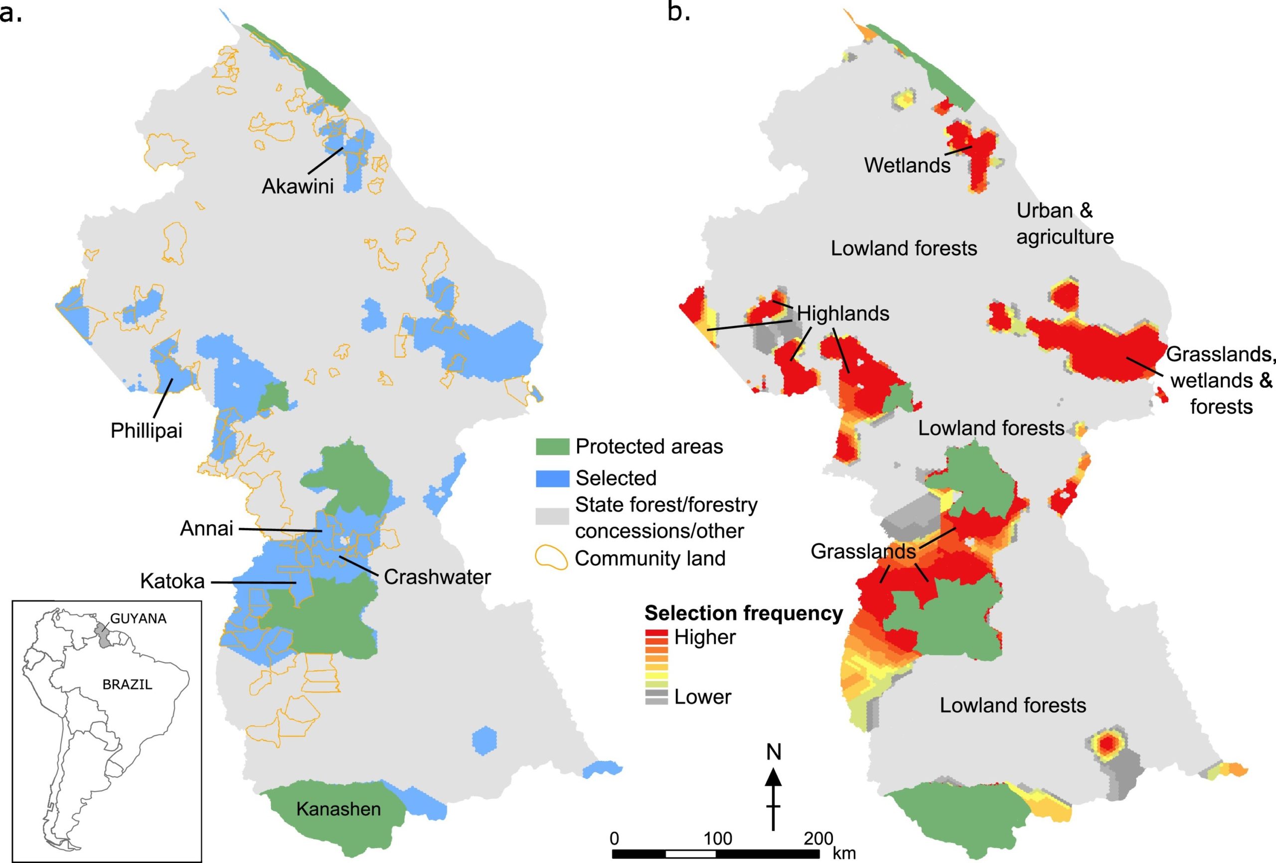
To guide the initial planning process, a group of stakeholders were formed from Government of Guyana agencies, academia, and Non-Governmental Organisations, and used a systematic conservation planning approach. The process identified priority areas to achieve conservation targets for 329 species and 17 vegetation types, while minimising opportunity costs (i.e. the choice of the best lower cost alternative) from the forestry, mining and agricultural industries. Given the importance of local communities, a method was developed to identify the most important community lands for meeting conservation targets. This provides a technique to help prioritise the engagement process for free prior and informed consent during the creation of new protected areas. The study serves as a benchmark for countries looking to undertake national-scale spatial conservation prioritisations to expand their protected area networks.
Recommendations from these consultations were that the conservation prioritisation should: i) focus on Guyana’s habitats and biodiversity, explicitly including threatened species; ii) incorporate opportunity costs; and iii) consider the role of community lands. The stakeholders also agreed that due to data availability, species distribution maps would need to be developed, and that the planning analysis should use Marxan, a software package designed to identify sets of priority areas that meet quantitative targets for specified conservation features, while minimising costs and maintaining connectivity. All stakeholders were kept up-to-date and remained involved as the spatial conservation prioritisation was developed and completed.
Results
To meet the CBD Aichi Target of 17%, Guyana needs to double the extent of its protected area network with an additional 8.5% (1.8 million ha). Based on meeting representation targets for biodiversity and vegetation, the conservation planning analysis identified approximately 20 priority areas for protection (Fig.a). In order to meet all the targets, the baseline analysis shows that an additional 14% (3 million ha) of Guyana’s terrestrial area would be required, bringing the extent of the protected area network to 22.5% (4.8 million ha) of the country. Of the additional priority area required for this, 8.8% (1.9 million ha) is state-owned land, and 5.2% (1.1 million ha) is community land. The analysis showed that to meet representation targets, approximately 750,000 ha would be required in the highlands; a little over 1 million ha in the south-western grasslands; 660,000 ha in the north-eastern mixed grasslands, forests and wetlands; 200,000 ha in north western wetlands; and 190,000 ha in the southern forests, with the remaining approximately 200,000 ha distributed in smaller patches throughout the country. To meet just the 17% target, the top priority areas are the largest patches with highest selection frequency scores, i.e. those selected in ≥ 90% of runs which are at least as big as the current smallest protected area in Guyana (Fig. b). These are two areas of highlands in the west, grasslands in the south-west that join two existing protected areas, mixed grasslands, forests and wetlands in the north-east, and wetlands in the north-west. Protecting these areas would mean every species and vegetation type would at least be represented within a protected area in Guyana. The government agencies responsible for protected area establishment are now working on establishing new protected areas, informed by this analysis. They have identified the south-western grasslands in the first round of the process, now undertaking further analysis and local stakeholder consultation.
References:
References
Bicknell et al. 2017. Designing protected area networks that translate international conservation commitments into national action.
Contact Information: