Marine Spatial Planning in St. Kitts and Nevis
Background
From 2010-2012, TNC collaborated with the St. Kitts and Nevis (SKN) Maritime Administration to conduct a marine zoning exercise that resulted in the drafting of a Marine Spatial Plan for St. Kitts and Nevis (SKN) under the Marine and Coastal Biodiversity Threat Abatement in the Eastern Caribbean (BioTA) project. Like many island nations in the Caribbean, SKN’s residents rely heavily on marine resources for their livelihoods; however, marine habitats and biodiversity are being threatened by rapid coastal development, overfishing, and other pressures. SKN was selected for MSP in the Caribbean for meeting a number of criteria, including government awareness and interest in marine zoning, potential existing policy instruments for implementing zoning, data availability, and the need to resolve existing conflicts.
Data and Zones
Extensive stakeholder engagement took place via targeted meetings with appropriate government ministries and departments as well as through a series of workshops to reach out to varied government and community groups. Through these workshops, the team was able to reach out to a variety of stakeholders, including high-level government officials, community groups, the private business sector, and fishers’ associations. During these workshops, stakeholders provided data on a variety of human uses, supplementing existing databases with local knowledge. Additionally, scientists added to existing data by conducting a fine scale benthic habitat mapping effort and reaching out to local fishers via a survey to map locations of fish landings.
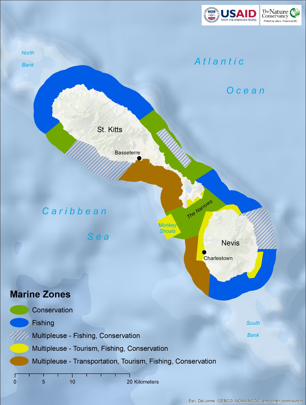
Using these data, the project team developed a series of decision support products, including a spatial database, an online mapping tool, a compatibility matrix, a series of maps depicting fisheries uses, benthic habitat, and compatibility among uses, and other products. These products were used to inform and develop a comprehensive marine zoning design which identified five use zones (conservation zone; fisheries zone; multiple use- fisheries and conservation; multiple use – tourism, fishing and conservation; and multiple use – transportation, tourism, fishing and conservation) approved by the stakeholders.
TNC brought in technical expertise to carry out spatial data evaluation and management and led additional data collection efforts including building datasets from expert knowledge, mapping benthic habitats, and surveying local fishers. These data were used in a Marxan with Zones analysis and other decision-support tools to support zoning design, which were vetted through a series of stakeholder meetings and workshops.
Understanding compatibility between marine uses
Identifying where to allow or prohibit activities within a seascape can be challenging. Understanding how these activities interact is vital to determining uses that are compatible and those that are not, and how this plays out in space. To achieve this understanding in the context of St. Kitts and Nevis, we engaged stakeholders in an organized discussion to document how compatible different marine uses were with one another. The discussion resulted in a detailed matrix quantifying the compatibility of various marine activities into compatibility scores. We produced a suite of compatibility maps by correlating the compatibility scores with spatial information associated with each activity. These maps became an integral part of the multi-objective analysis and played a key role for considering how to accommodate new locations for marine activities.
Prior to running Marxan with Zones, a workshop was held with stakeholders to review all data input and model parameters. Several important decisions were made during this workshop including the final list of marine zones that were used in the model (see Zoning Table).
Scenarios and comparisons
Marxan with Zones was implemented to help inform the development of a multi-objective marine zoning design for SKN across several scenarios. Comparing the three scenarios provides a way to analyze zoning patterns and determine the spatial extent of core zoning areas based on pre-defined parameters and inputs. One of the primary needs of this project was to assimilate the vast amount of fisher survey data, developing a quantitative approach for identifying core fishing areas. Another need was to evaluate the highly detailed coastal benthic habitat data and identify the optimal areas where marine resources could be conserved and set aside as “replenishment” zones, benefiting fishers, tourism operators, and the overall ecological integrity of the coastal zone. While the fisher surveys provided information on where fishing activities was likely to take place, the benthic habitat data provided equally valuable information on important conservation areas. Naturally, these two objectives contain a large amount of spatial overlap since the majority of fish are typically found in viable benthic habitats.
Initial runs for the variable goal scenario proved difficult meeting high goals (e.g. 90%) that were set for both fishing and conservation objectives. As assumed, these two areas often fall within the same areas; consequently, it is difficult to meet high goals set for both fishing and conservation objectives. However, when objectives goals are reduced by 20%, several patterns emerged that revealed subtle, yet important core fishing and conservation areas. Although these core areas vary in terms of size and extent between scenarios, several patterns emerged that can be evaluated in terms of the fishing intensity and abundance of benthic habitats.
|
MARINE ZONE |
MANAGEMENT OBJECTIVE These zones represent areas designated for: |
|
1. Fishing Priority |
Enhanced productivity and ongoing replenishment of key species Areas of both open and closed to fishing· Areas where select gear or access restrictions apply Unrestricted access to landing and mooring facilities for fishers |
|
2. Conservation Priority |
Protection of key submerged marine resources (e.g. critical habitats, species, nursery grounds, feeding, and reproduction areas) Protection of coastal resources (e.gz. beaches, mangroves, coastal wetlands, lagoons, salt ponds) Protection of terrestrial resources critical for marine health (e.g. watershed protection, 120ft beach set back, Restored critical habitat (e.g. mangrove and nursery habitat) Protection of culturally important marine areas |
|
3. Tourism Priority |
Tourism activities such as swimming, snorkeling, scuba diving, jet skiing, surfing, and windsurfing Recreational boating such as sailing and jet boats with adequate beach and pier access as well as moorings Recreational fishing (near-shore and game) for large and variable fish species Ecotourism marine-based activities such as turtle and sea birds watching and diving. Areas designated for future tourism infrastructure expansion (hotels, golf courses, road access) Areas where future development is not allowed |
|
4. Industrial/Transportation |
Sufficient space for energy generation and transmission for local consumption and export Coastal engineering (including “grey” (e.g. sea walls, beach replenishment) and “green” (e.g. mangrove reforestation) solutions Includes both sustainable and no development options Distinct identification and demarcation of ferry and shipping lanes, mooring and anchorage areas (commercial and recreational) Future marine development sites |
|
5. Multiple Use |
Areas where any of the above activities can be designated |
Zoning designs are most effective when the boundaries are defined by those who will be involved in the management and enforcement of a plan. Making scientifically sound information available to managers and stakeholders enables informed decisions about boundary locations and increases the likelihood of local buy in. A variety of stakeholders participated in a series of workshops to review decision support products and use them to discuss zoning boundaries and guide the zoning design. The zoning scenarios as well as the compatibility maps were considered side by side. Participants worked together to combine these tools, through a facilitated and iterative process, with their individual knowledge of needs and desires of individual sectors to arrive at a consensus on a draft zoning design.
The activities and products described above helped provide an integrated view of marine space and uses for St. Kitts and Nevis. The stakeholders successfully met the challenge of developing a shared vision for the waters surrounding their island nation, considering a wide variety of information and navigating difficult conversations around the sharing of ocean space. As a result of the marine zoning process outlined above, each sector in St. Kitts and Nevis: tourism, fisheries, conservation, industry, and transportation, gained a greater understanding of how to best integrate their needs to make the best use of the marine space. The process ultimately culminated in a stakeholder-generated zoning design that describes the optimal allocation for a number of ocean uses.
On August 18th 2016, the Honorable Eugene Hamilton approved on behalf of the Government of the Federation of Saint Christopher and Nevis the declaration of the St. Kitts and Nevis Marine Management Area as defined by the two (2) miles radius of sea water around the St. Kitts and Nevis’ coastline including the Monkey Shoals area to be managed by the Department of Marine Resources as the entity with jurisdiction of the Federal Waters of St. Kitts and Nevis as indicated in the Fisheries, Aquaculture and Marine Resources Act (FAMRA) 2016.
References:
Contact Information: