
Coral cover in the Coral Triangle
Background
Mega‐diverse coral reef ecosystems are declining globally, necessitating conservation prioritizations to protect biodiversity and ecosystem services of sites with high functional integrity to promote persistence. In practice however, the design of marine‐protected area (MPA) systems often relies on broad classifications of habitat class and size, making the assumption that all reefs are of comparable condition. We explored the impact of this assumption through a novel, pragmatic approach for incorporating variability in coral cover in a large‐scale regional spatial prioritization plan. The Coral Triangle is the globally recognized epicentre of marine biodiversity, encompassing almost 6 million square km of ocean and coastal waters surrounding Indonesia, Malaysia, Papua New Guinea, the Philippines, Timor Leste, and the Solomon Islands. The Coral Triangle Initiative on Coral Reefs, Fisheries and Food Security (CTI‐CFF) unites the 6 nations in conserving the region's coastal and marine resources. Significant effort has been invested in the implementation of MPAs at local and national levels, and a spatial prioritization framework has been proposed to facilitate ongoing regional MPA planning.
Predicting coral cover
We developed a spatially explicit predictive model of hard coral cover based on freely available macro‐ecological data to generate a complete regional map of coral cover as a proxy for reef condition. Live hard coral cover, a common proxy for reef condition, was modelled at the level of planning units using a generalized additive model. The aims were to (a) identify significant drivers of coral cover using existing remotely sensed and observational data; and (b) generate predictions for previously unsurveyed planning units to produce a region‐wide map of coral cover estimates. Georeferenced coral cover data were collated from various sources, comprising 6,412 reef surveys from 3,820 sites. Of these, 3,141 had been surveyed just once between 1996 and 2016. We calculated mean coral cover, aggregating information from multiple survey sites within a planning unit. If multiple records were available for a single survey site, we used the most recent data. We then constructed a statistical model of coral cover, based on biotic and abiotic factors known to impact the distribution of hard scleractinian corals, available at the required spatial coverage and scale. We then incorporated this information in spatial conservation prioritization software Marxan to design an MPA system that meets specific conservation objectives

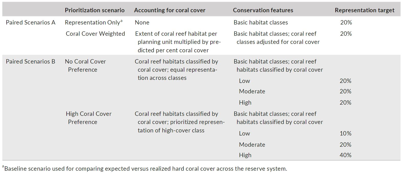
Spatial prioritization scenarios
We used Marxan to select sets of planning units which achieve explicit conservation targets, while minimizing the overall cost of the proposed MPA system for two sets of paired prioritization scenarios that account for coral cover in different ways. All scenarios were based on the existing planning framework for MPA expansion across the Coral Triangle, consisting of 17,264 planning units, 10 × 10 km in size. Human population density in coastal areas and artisanal fishing effort in marine planning units served as the best available proxies for opportunity cost at this scale. We applied a minimal boundary length modifier (BLM = 0.2), producing an efficient level of compactness, to all scenarios.
Results
The persistence of marine biodiversity can be at risk when planning does not account for ecological context, as sites selected for conservation action may be in poor condition and unlikely to contribute effectively towards conservation outcomes. Yet to date, habitat condition or proxies thereof have rarely been incorporated into MPA design (but see Klein et al., 2013). At large spatial scales in particular, prioritizations are constrained by sparse habitat condition data and typically make the tacit assumption that all reefs have equal conservation value. We show that this may result in MPA systems that overestimate actual outputs by up to 64%. Furthermore, because prioritization scenarios with low representation targets (e.g., 20%) allow considerable flexibility, selection of planning units for specific habitat types may be driven by minimizing cost when information about condition is not included. It may be reasonable to expect that low‐cost reef areas, because they are typically remote and less affected by human activity, incidentally represent high‐quality habitat. Yet our findings suggest that explicitly incorporating coral cover data in the planning process prioritized reefs in different locations, resulting in an MPA system with improved overall habitat quality.
This study shows that including habitat condition in a large‐scale marine spatial prioritization is feasible within time and resource constraints, and calls for increased implementation, and evaluation, of such ecologically relevant planning approaches to enhance potential conservation effectiveness.


References:
References
Vercammen, Ans, et al. "Evaluating the impact of accounting for coral cover in large‐scale marine conservation prioritizations." Diversity and Distributions 25.10 (2019): 1564-1574.
Contact Information:

Ans Vercammen
Centre for Environmental Policy, Imperial College London


