Land-Sea Planning in Papua New Guinea
Background
This assessment used Marxan to underpin a systematic conservation planning approach in Papua New Guinea. The goal was to identify sets of areas that meet explicit targets aligned with international and national policies, particularly the Convention on Biological Diversity’s Aichi target 11 which aims to protect 17% of terrestrial ecosystems.
It is worth noting that the assessment focused on biological diversity (e.g., through inclusion of habitats (terrestrial ecosystems and benthic habitats), climate refuges, and rare and range restricted species distributions). While other features such as geological diversity and cultural diversity are aspects of diversity worth conserving, the assessment was constrained by available data. Geological and cultural diversity were captured, where possible, through the expert workshops. However, a more comprehensive assessment of these aspects of diversity would include mapped features across PNG.
Innovation
A key advancement was the use of Marxan with Connectivity to identify priorities across land and sea taking into account asymmetric landsea connections.

Who were the partners?
Papua New Guinea Conservation and Environment Protection Authority (CEPA), Global Environment Facility, United Nations Development Programme, The University of Queensland and The Nature Conservancy.
Results
The assessment was completed between 2015 and 2017 but built on substantial planning efforts in the marine realm (2012-2014), and terrestrial realm (2009-2011). This assessment identifies areas of conservation priority, however it does not dictate the types of activities within these sites. Translation of these mapped areas into conservation action is being undertaken by the Conservation and Environment Protection Authority (CEPA) in collaboration with relevant local partners (e.g. local communities and customary landowners to identify socially acceptable and locally relevant management arrangements). There are a range of conservation strategies that can be used to protect sites identified as conservation priorities within this assessment; these range from legal mechanisms to informal community based arrangements to management planning and activities. The primary objective of this assessment was to provide an updated set of conservation priorities by integrating Terrestrial and Marine Programme of Works on Protected Areas
(PoWPA) in PNG; this set of conservation priorities (see Figure 1) can be used as a roadmap for meeting conservation targets that fulfill PNG’s global conservation commitments (e.g. under the CBD Aichi 11 targets) as well as national targets (such as the Protected Areas
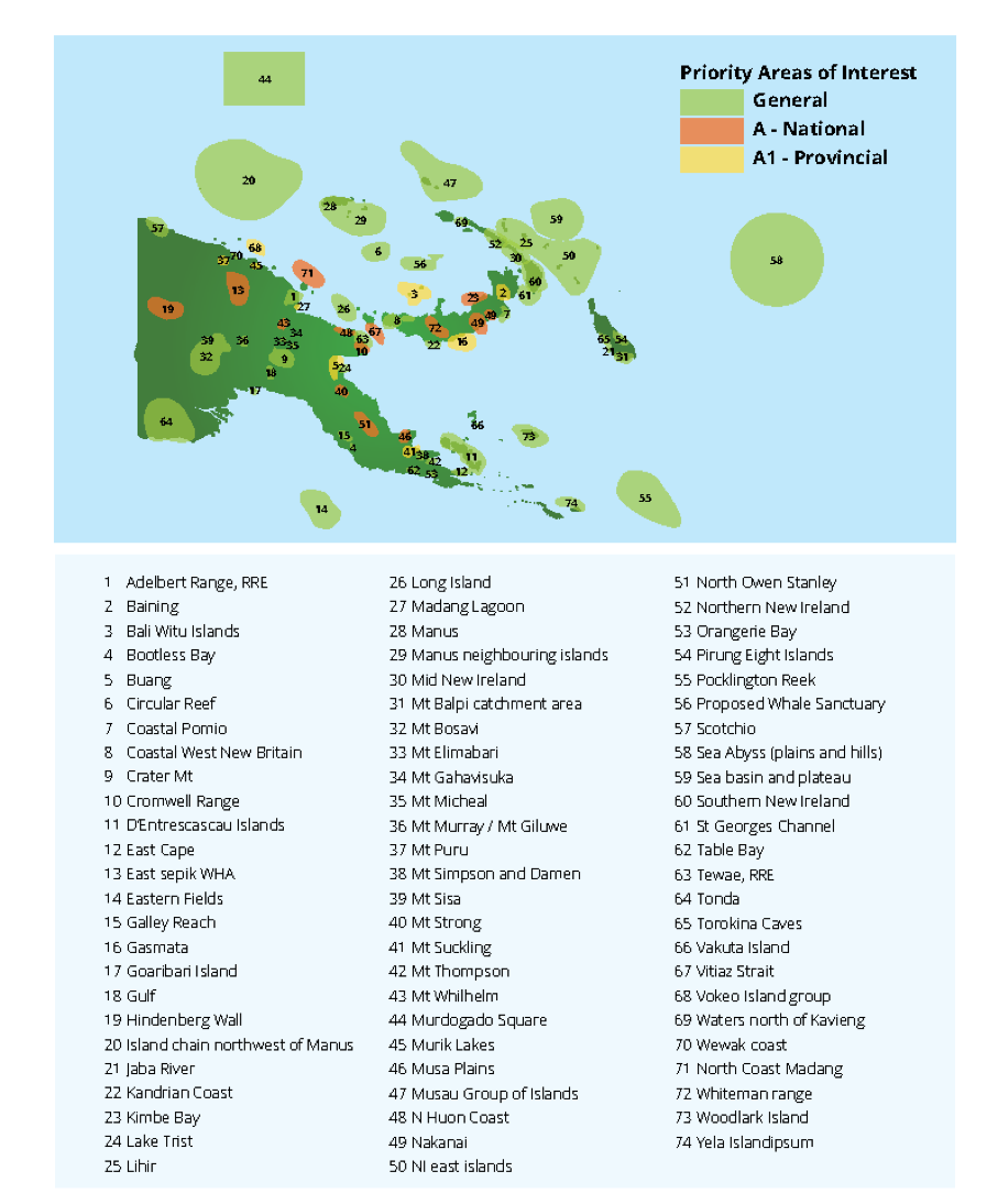
Policy). These areas were vetted by experts through a series of workshops and a subset of these priorities, ‘Areas of Interest’ (AOIs), were identified as areas critical for immediate conservation attention (Figure 2). Communication products such as individual fact sheets describing the conservation values within these areas were produced to facilitate implementation of conservation programs within these areas. They are the focus of current efforts in scoping conservation options and partnering with possible funders.
References:
References
Adams, VM., Tulloch, VJ., & Possingham, HP. 2017. Land-sea conservation assessment
for Papua New Guinea. DOI: 10.13140/RG.2.2.26219.13606
Contact Information:

Vanessa Adams
vm.adams@utas.edu.au

