
Software
Marxan is a family of software that can be applied to different types of planning challenges. Over the years, Marxan has grown from its standard two zone application to consider more complex challenges like incorporating connectivity, probabilities and multiple zones. Along the way, Marxan's user community has also built plug-ins and interfaces to assist with planning projects. See below for the suite of Marxan software and resources available for free download.
MARXAN
Marxan is the most widely used decision-support software for conservation planning globally, and has been used to build marine and terrestrial conservation systems covering approximately 5% of the Earth's surface. Marxan supports the design of cost-efficient networks that meet conservation targets for biodiversity.
Beyond protected area network design, Marxan has been applied to a range of conservation planning challenges, from designing optimal poaching patrols for game reserves and identifying where to conserve essential ecosystem services, to helping with transboundary ocean planning and understanding where transnational collaborations might best be prioritized to achieve conservation goals.
For an introduction to Marxan using ArcGIS developed by The University of Queensland and Pacmara, please download the Tutorial. For an introduction to Marxan using the open source GIS software QGIS, please see "Companion Tools" and the CLUZ introduction presentation here.
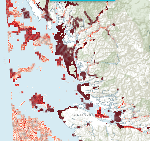
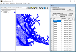
Example of the Selection Frequency map from the British Columbia case-study available in the Marxan tutorial.
Cite Marxan:
Ball, I.R., H.P. Possingham, and M. Watts. 2009. Marxan and relatives: Software for spatial conservation prioritisation. Chapter 14: Pages 185-195 in Spatial conservation prioritisation: Quantitative methods and computational tools. Eds Moilanen, A., K.A. Wilson, and H.P. Possingham. Oxford University Press, Oxford, UK.
Key References
Coming Soon
Marxan Web is a decision-support platform for doing Systematic Conservation Planning over the web and for sharing the results amongst stakeholders and the conservation community. It builds upon the existing Marxan software and offers the following new features and benefits:
- Streamlined access to spatial data layers from our partners (in development)
- Training and demonstration tutorials (in development)
- Built in geoprocessing and file construction
- Improved mapping and visualization capabilities
- Sharing and learning with other users
Marxan web is being developed in collaboration with The Nature Conservancy and the BIOPAMA project of the European Commission's Joint Research Centre. Pilot testing is currently underway.
![]()


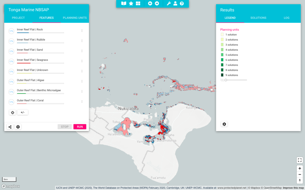
Snapshot of the Marxan web interface where you can set targets for features, visualize outputs, change parameters and manage projects all in one location.
Marxan with Zones has the same functionality as Marxan but extends on the range of problems the software can solve and allows for the incorporation of multiple costs and zones into a systematic planning framework. Applications could be zoning for marine protected areas with various protection levels or landscapes that balance agriculture, biodiversity protection, and sustainable forestry zones. Marxan with Zones assigns each planning unit in a study region to a particular zone in order to meet a number of ecological, social and economic objectives at a minimum total cost.
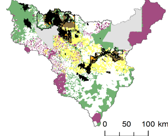
Example of different zoning allocation using Marxan with Zones. Image from V. Adams
Cite Marxan with Zones
Watts, M.E, I.R. Ball, R.R. Stewart, C.J. Klein, K. Wilson, C. Steinback, R. Lourival, L. Kircher, and H.P. Possingham. 2009. Marxan with Zones: software for optimal conservation based land- and sea-use zoning, Environmental Modelling & Software (2009), doi:10.1016/j.envsoft.2009.06.005
Key References
Marxan with Connectivity is an extension of the Marxan software family that allows for more sophisticated connectivity considerations in spatial planning. For example, sites may be connected through processes such as larval dispersal, animal migrations, and genetic flows which are desirable objectives in conservation plans. Marxan with Connectivity has been applied in freshwater, marine, terrestrial and land-sea systems to conserve sites that may be spatially distanced but ecologically connected.
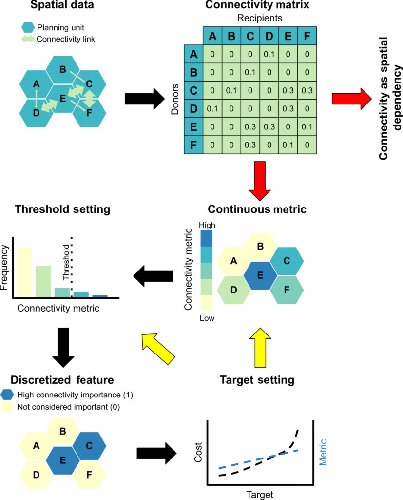
Schematic of different ways to incorporate connectivity data into Marxan (from Daigle et al. 2020).
Key References
Marxan with Probability (MarProb) is Marxan with an additional objective function term that incorporates the probability of a site being destroyed at some point in the future. This function helps plan for persistence in protected area networks (See Threats Formulation and Game et al. (2008)).
Similar to Marxan with Connectivity, Marxan with Probabilities is available in Marxan versions 2.43 and above. To call this additional function, you need to edit the input.dat file and compile the appropriate input files. See software documents and datasets for more details.
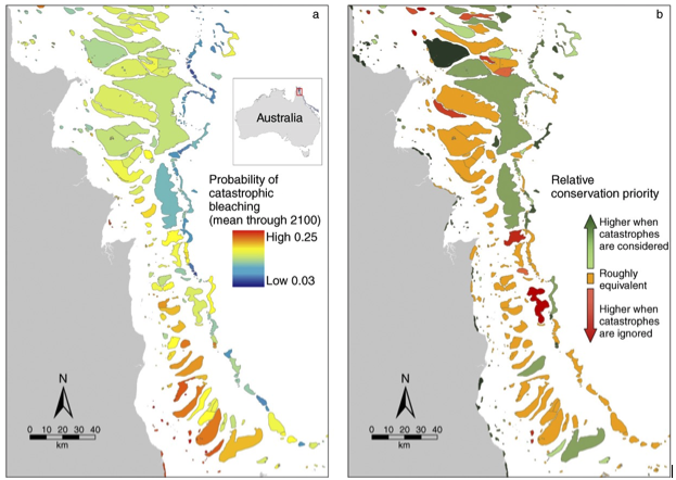
Example of how Marxan with Probabilities can be used to understand priorities given the likelihood of catastrophic climate change.
Key References
Zonae Cogito
Zonae Cogito is a freely available software package that help manage and visualise Marxan projects. The interface streamlines and simplifies the development and evaluation of alternative planning scenarios, allows direct editing to input files, calibrates parameters, and helps users easily access important output files for evaluation.
Software
Software Documents
Key References
CLUZ
CLUZ (Conservation Land-Use Zoning software) is a QGIS plug-in that allows users to design protected area networks and other conservation landscapes and seascapes. It can be used for on-screen planning and also acts as a link for the Marxan conservation planning software. It was developed by Bob Smith and funded by the UK Government’s Darwin Initiative.
Software
Citation
MARXAN TOOLBOXES
Helpful tools developed by Trevor Wiens from Apropos Information Systems are available for both ArcGIS and QGIS users.
ArcMarxan Toolbox
The ArcMarxan Toolbox is a free / open source python toolbox for ArcMap 10.2 and above that makes creating input files for Marxan simple, quick and easy.
QGIS Toolbox
The QMarxan Toolbox is a QGIS plugin that provides a set of processing tools for QGIS 3.x for Marxan data preparation, export to Marxan, calibration and analysis of results. The current version is 2.0.
QMarxan can be found in the QGIS repository. To install:
- In QGIS, click the "Plugins" menu, and click "Manage and Install Plugins..."
- In the search box, enter “QMarxan Toolbox”, select the tool and click on “Install plugin”. The close the window.
- Click on the toolbox If you successfully installed the tools, you should see the QMarxan Toolbox (1.1) listed in the toolbox panel.
PRIORITIZR
Systematic Conservation Prioritization in R - The prioritizr R package uses integer linear programming (ILP) techniques to provide a flexible interface for building and solving conservation planning problems. It supports a broad range of objectives, constraints, and penalties that can be used to custom-tailor conservation planning problems to the specific needs of a conservation planning exercise. Once built, conservation planning problems can be solved using a variety of commercial and open-source exact algorithm solvers. In contrast to the algorithms conventionally used to solve conservation problems, such as heuristics or simulated annealing, the exact algorithms used here are guaranteed to find optimal solutions. Furthermore, conservation problems can be constructed to optimize the spatial allocation of different management actions or zones, meaning that conservation practitioners can identify solutions that benefit multiple stakeholders. Finally, this package has the functionality to read input data formatted for the Marxan conservation planning program, and find much cheaper solutions in a much shorter period of time than Marxan.
Software
Citation
Register Your Expression of Interest for Teaching Resources
We are currently working to develop an online teaching application, hosted in the cloud, with curated case-studies to help you teach the concepts of spatial planning with Marxan. Once completed, this resource will be available to you to offer custom training in conservation planning theory. To register your interest in using this application in your practice or teaching, please fill out the below form and we will be in touch with further instructions to use this resource. A standard Marxan course using desktop tools is available in the Marxan Tutorial.